


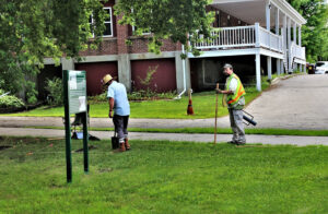
CEMML archaeological survey explores early 20th century history of Fort McCoy
An archaeological survey conducted by CEMML personnel in the summer of 2022 was initially meant to investigate the creation of several hundred concrete tent pads at Fort McCoy, Wisconsin. Research into the tent pads, dating from around the early 20th century, also unearthed additional information about other possible known archaeological features and sites around what is referred to as “Old Camp McCoy.”
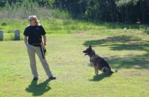
Canine detectives help locate long-forgotten burials at a Virginia military base
Mulberry Island, Virginia, the location of Joint Base Langley-Eustis, has a long history of human habitation, dating back 10,000 years. The area has more than 230 archaeological sites, including cemeteries with unmarked graves. CEMML, in partnership with the Fort Eustis Cultural Resources Program, is using human remains detection dogs to help identify unmarked burial sites to better understand, honor, and preserve the area’s rich history.
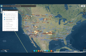
CEMML partnership helps ensure Native American voices are heard in military planning
Much of the roughly 26 million acres that the Department of Defense oversees nationwide was once occupied by Native American tribes. Military installations are legally required to consult with interested tribes when carrying out projects that affect natural and cultural resources. A tool developed by CEMML and the Air Force Civil Engineer Center helps determine which tribes may have an interest in an installation’s land or airspace.